Total Area: 676,578 sq km
Land Area: 653,508 sq km
Water Area: 23,070 sq km
Size Compared to the U.S.A: Slightly smaller than Texas
Borders: Bangladesh 271 km, China 2,129 km, India 1,468 km, Laos 238 km, Thailand 2,416 km
Total Distance Of All Land Boundaries: 6,522 km
Total Coastline Distance: 1,930 km
Climate: Tropical monsoon; cloudy, rainy, hot, humid summers Monsoons in the southwest from June to September; less cloudy, scant rainfall, mild temperatures, low humidity during winter, monsoons in the northwest from December to April
Terrain: Low lands in the center, surrounded by rugged highlands
Average Elevation: 702 m
Lowest point: Andaman Sea/Bay of Bengal 0 m
Highest point: Gamlang Razi 5,870 m
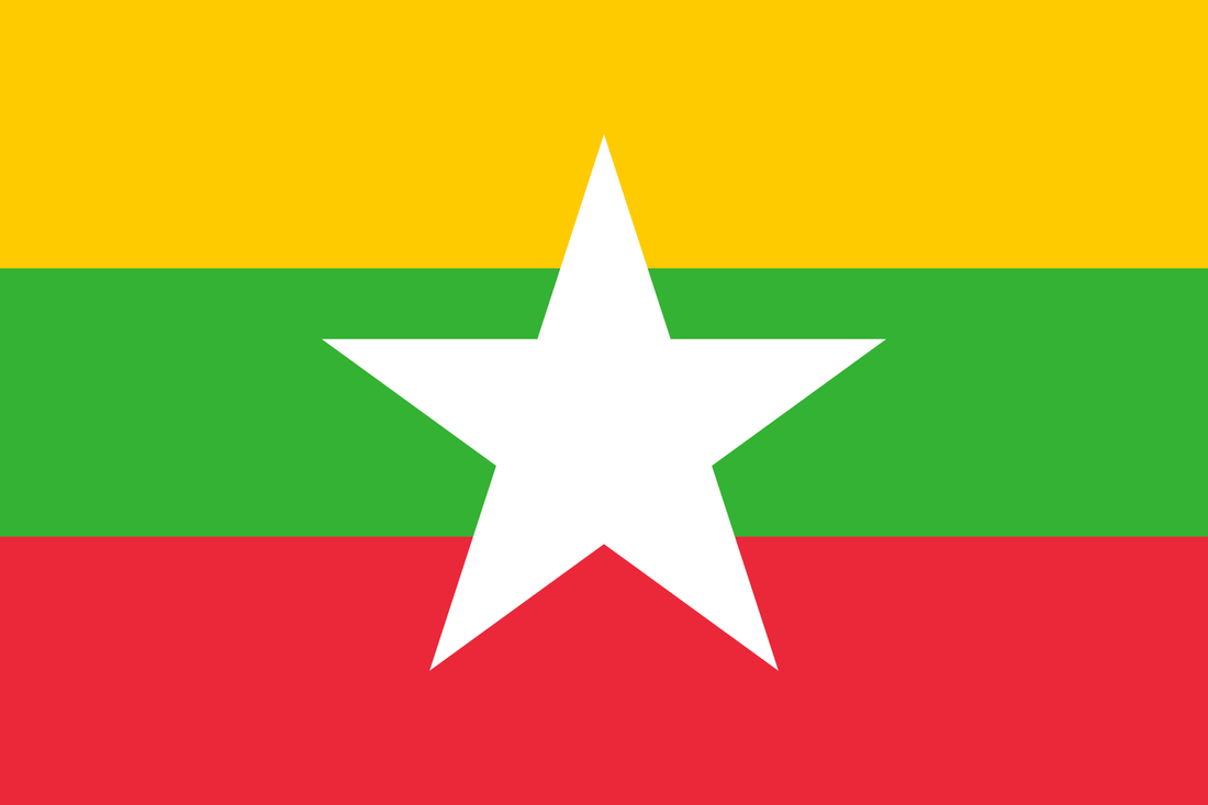
Flag of Myanmar
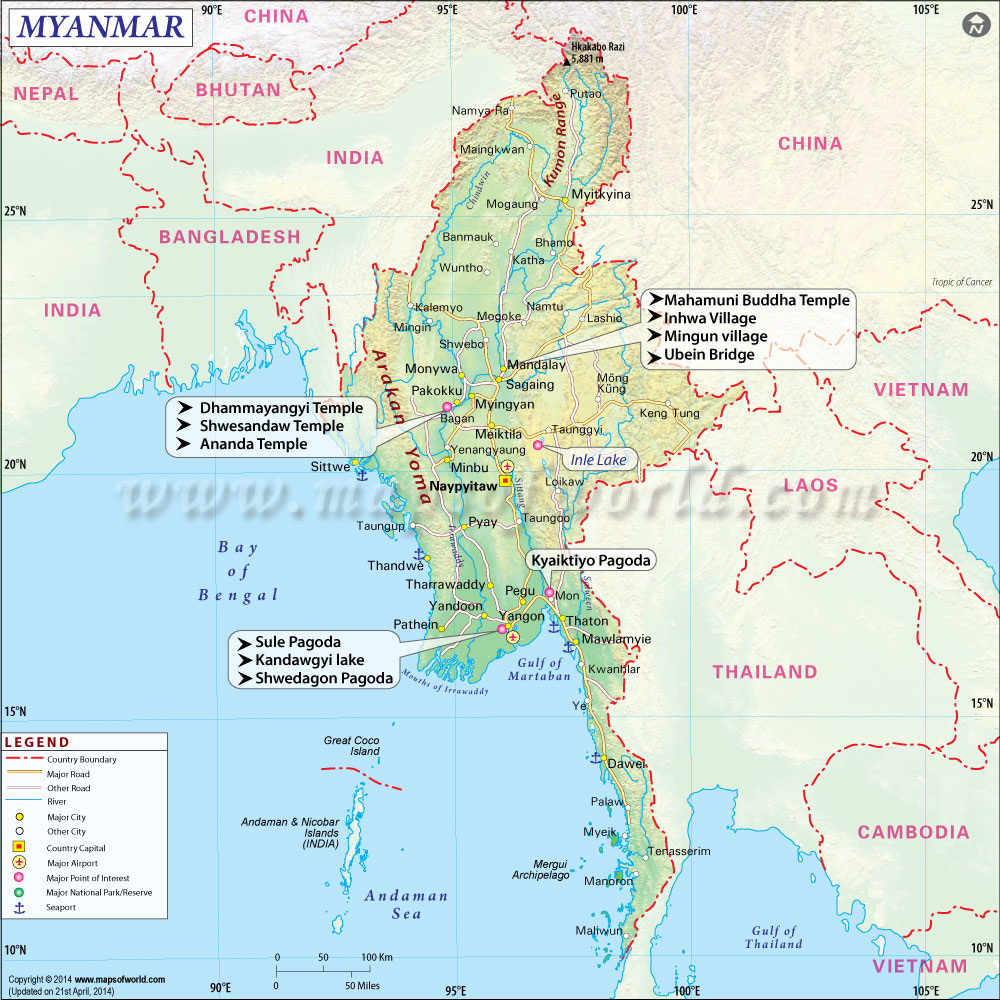
Map of Myanmar
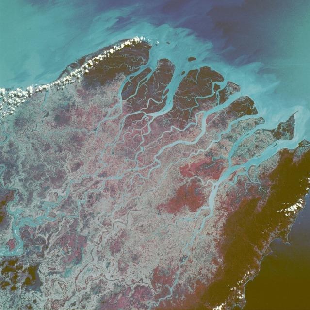
Physical view of Myanmar
|
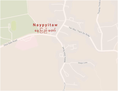
Capital of Myanmar
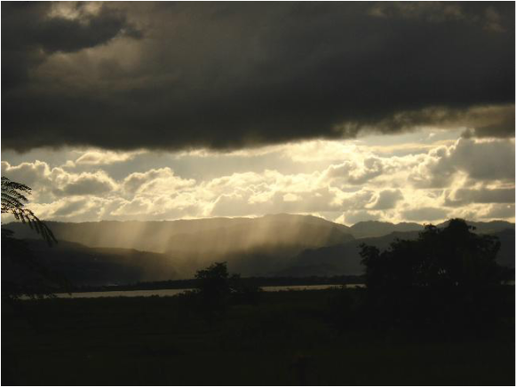
An example of the climate of Myanmar
|
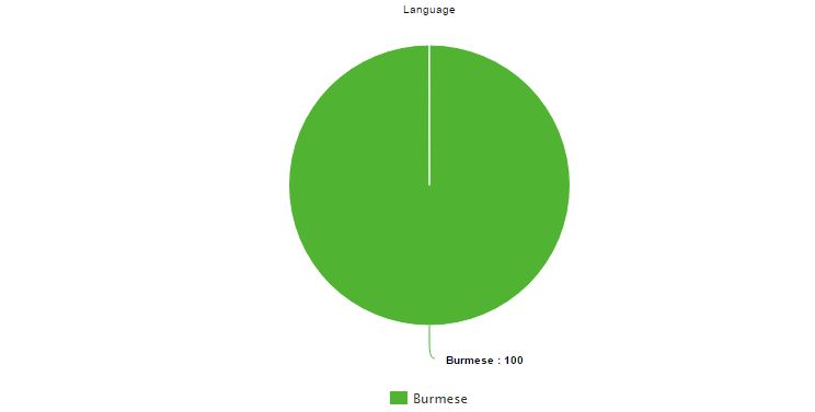
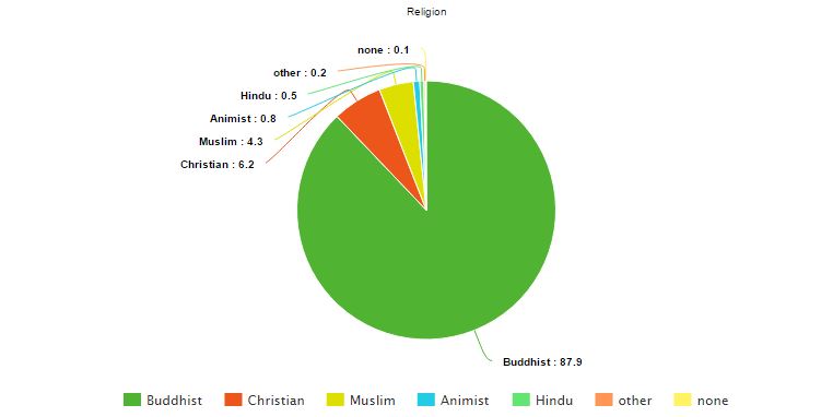
Population:
Population (Mid-2012): 56,890,418 people
Density (people per sq. km): 81.82 people per sq. kilometer
Net Migration Rate(# per 1000 people): -0.3 migrant(s)/1,000 population
Birth Rate (# per 1000 people): 18.2 births/1,000 population
Death Rate (# per 1000 people): 7.9 deaths/1,000 population
Rate of Natural Increase: 10.3
Population Growth Rate: 1%
Infant Mortality Rate (# of deaths per 1000 live births): 42.2 deaths/1,000 live births
Total Fertility Rate (average # of children per woman): 2.15 children born/woman
Population Age <15 %: 25.77%
Population Ages 65+ %: 5.47%
Dependency Rate (add together Population Age <15 % and Ages 65+%): 31.24%
Life Expectancy at Birth (total): 66.6 years
Life Expectancy at Birth Females: 69.2 years
Life Expectancy at Birth Males: 64.2 years
Primary School Completion Rate Females: 67.26%
Primary School Completion Rate Males: 68.54%
Secondary School Enrollment Net Females: 48.63%
Secondary School Enrollment Net Males: 47.87%
GNI PPP per capita in US $: 1,200.00 USD
Economically Active Females 15+: 63%
Economically Active Males 15+: 85%
Mobile Phone Subscribers (# per 100): 54.03
Motor Vehicles (# per 1000): 7
Undernourished Population: 14.2%
Underweight Children Under Age 5: NA
HIV/AIDS Among People Ages 15 - 49: 224,800 people
|
|
|
|
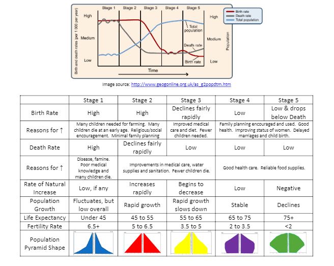
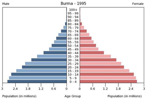
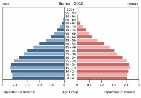
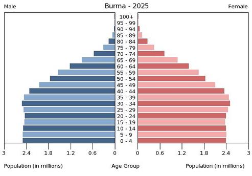
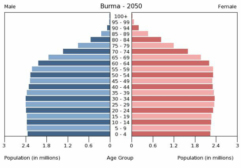
Myanmar is in the third stage of the demographic transition model. It's population pyramid makes an almost identical shape to the example given in the above chart. It is also shown that Myanmar has a lower natural increase rate then the previous country of Laos. This signifies that the birth rate has slowed down, which it has. However Myanmar has not progressed all the way to stage four because of the poor financial state of the country, which prevents the citizens and technology from developing in some ways.
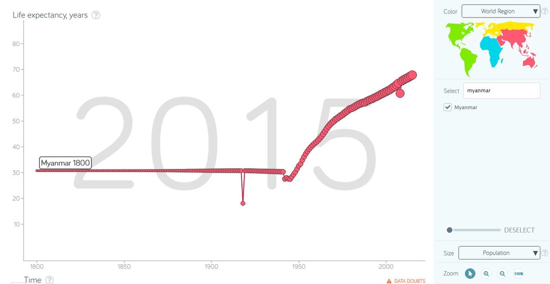
https://www.gapminder.org/tools/#_chart-type=bubbles&state_time_end=2015;&entities_select@_geo=mmr&trailStartTime=1800;;&opacitySelectDim=0.00;&marker_axis%2F_y_zoomedMin:1;&axis%2F_x_which=time&domainMin=1800&domainMax=2015&zoomedMin=1800&zoomedMax=2015&scaleType=time
This graph compares time to life expectancy. Myanmar, being a much less developed country, still developing in fact, had a steady life expectancy at about thirty for a long time. The only difference was that somewhere around the twenties the expectancy dropped by about 10 years. This could have been due to a conflict or an outbreak. Then later in the twenty first century the expectancy grew. This is due to medical breakthroughs diffusing to Myanmar.
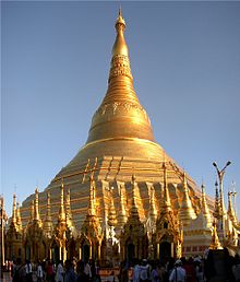
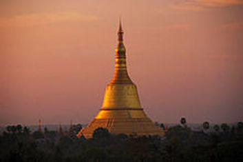
Shwedagon Pagoda is the most sacred Buddhist pagoda in Myanmar, as it is believed to contain relics of the four previous Buddhas of the present kalpa. These relics include the staff of Kakusandha, the water filter of Konagamana, a piece of the robe of Kassapa, and eight strands of hair from the head of Gautama.
The destination of the competitors is the Shwemawdaw Pagoda palace. The Shwemawdaw Paya was originally built around the 10th century, C.E. It was destroyed several times due to earthquakes, including one in 1917 and another in 1930. Portions of the fallen pre-1917 version of the Paya remain at the site. The original version of the pagoda was approximately 70 feet (21 m) tall
3 Pictures to Show Myanmar Culture:
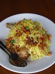
Burmese Cuisine Burmese Biryani
|
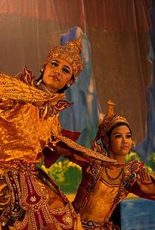
A theatrical performance of the Mon dance
|
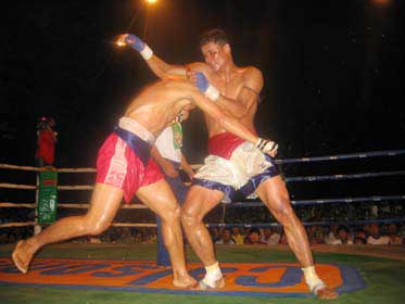
Myanmar Boxing
Culture Journal Report:
"Culture of Myanmar" - http://www.everyculture.com/Bo-Co/Burma.html
Written in 2016 by multiple contributors
The social classes are a decided factor in Myanmar. Not only is poverty widespread, there is marked inequality. Essentially, the society is divided into a tiny elite, a fairly small middle class, and a large number of very poor people. The government is a differently in the developing country. The military has ruled the country since 1962. In the face of growing opposition to the government and its socialist policies, Ne Win and President San Yu resigned in July 1988, and widespread civil unrest followed. Both men and women do agricultural work, but individual tasks are often gender-specific. Men prepare the land for planting and sow seeds, and women transplant rice seedlings. Harvesting is done by both men and women. The only varying idea in Myanmar is that the men and women do similar jobs because of the overwhelming poverty
Politics:
Conventional Long Form: Union of Burma
Capital cities: Rangoon
Type of government: parliamentary republic
Date of Independence: 4 January 1948 (from the UK)
National Holidays: Independence Day, 4 January (1948); Union Day, 12 February (1947)
Chief of State: President Htin Kyaw
Capital cities: Rangoon
Type of government: parliamentary republic
Date of Independence: 4 January 1948 (from the UK)
National Holidays: Independence Day, 4 January (1948); Union Day, 12 February (1947)
Chief of State: President Htin Kyaw

Head of Government: President Htin Kyaw
Description of Executive Branch: Cabinet appointments shared by the president and the commander-in-chief
Description of Legislative Branch:bicameral Assembly of the Union or Pyidaungsu consists of an upper house and lower house
Description of Judicial Branch: Supreme Court of the Union (consists of the chief justice and 7-11 judges)
Suffrage: 18 years of age; universal
U.S. Ambassador: Aung Lynn
Embassy Location in Myanmar: 110 University Avenue, Kamayut Township, Rangoon
U.S. Embassy Location: 2300 S Street NW, Washington, DC 20008
U.S. Ambassador from Myanmar: Scot Marciel
Flag meaning: the design revives the triband colors used by Burma from 1943-45, during the Japanese occupation
National Symbols: chinthe (mythical lion); national colors: yellow, green, red, white
International Disputes: over half of Burma's population consists of diverse ethnic groups who have substantial numbers of kin in neighboring countries; the Naf River on the border with Bangladesh serves as a smuggling and illegal transit route
Quantity of Refugees: Not applicable
Internally displaced persons: 644,000
Stateless persons: 938,000
Drug trafficking: world's third largest producer of illicit opium with an estimated production in 2012 of 690 metric tons, an increase of 13% over 2011, and poppy cultivation in 2012 totaled 51,000 hectares
Political Journal Report:
Title: The Missing Middle
Author: None listed
Published: February 25, 2017
Link: http://www.economist.com/news/asia/21717409-despite-many-prominent-female-politicians-big-sex-divide-endures-women-south-asian-politics?zid=309&ah=80dcf288b8561b012f603b9fd9577f0e
Article Analysis: The article not only tackles politics in Myanmar but it also discusses the sexism grilled into the political system. The fact that women are not allowed in politics and therefor have no representation in the decisions that have been made by the government officials in the country. The article talks about how the culture considers it taboo for women to have a position of such power and therefor it cannot be allowed.
Agriculture:
Total Area: 676,578 sq km
Land Area: 653,508 sq km
Water Area: 23,070 sq km
Climate Description: tropical monsoon; cloudy, rainy, hot, humid summers (southwest monsoon, June to September); less cloudy, scant rainfall, mild temperatures, lower humidity during winter (northeast monsoon, December to April)
Terrain Description: central lowlands ringed by steep, rugged highlands
Arable Land Use: 16.5%
Permanent Crop Use: 2.2%
Irrigated Land: 22,950 sq km
Total Renewable Water Sources: Not listed
Total Freshwater Withdrawal: Not listed
Per Person Freshwater Withdrawal: Not listed
Natural Hazards: destructive earthquakes and cyclones; flooding and landslides common during rainy season (June to September); periodic droughts
Environmental Current Issues: deforestation; industrial pollution of air, soil, and water; inadequate sanitation and water treatment contribute to disease
Total Labor Force: 37.15 million
% of Labor Force in Agriculture: 70%
Agriculture Products Description: rice, pulses, beans, sesame, groundnuts; sugarcane; fish and fish products; hardwood
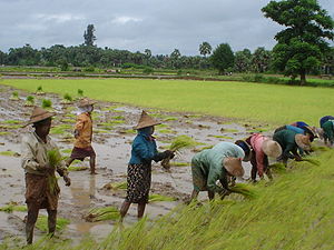
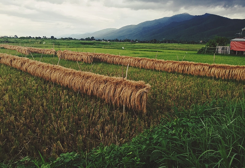
Depicts the process of the harvest of rice in Myanmar
|
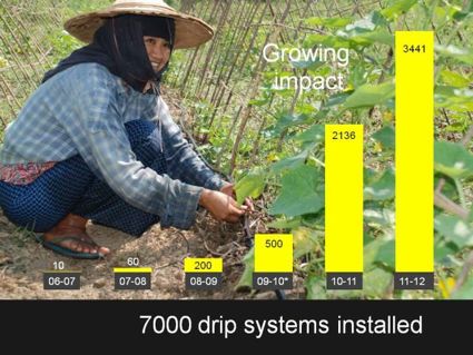
Graphic showing the increase in technology used in agriculture in Myanmar
|
|
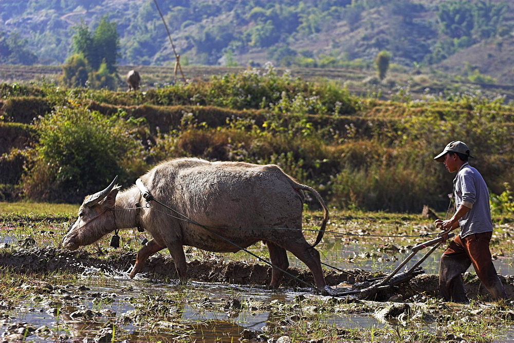
Example of how livestock is used in agriculture
|
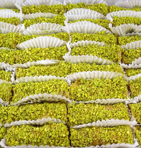
Pistachio crop yield in Myanmar
|
Development and Industry:
Population: 52,147,000
GNI PPP Per Capita (US$): 0
Women as % of Nonfarm Wage Earners: 0
Women as % of Parliament: 5%
CO2 Emissions Per Capita (metric tons): 2,680,000
Death Due to Non-Communicable Diseases: 40%
Births Attended by Skill Health Personnel (%): 57%
Democracy: CPIA Gender Equality Rating: N/A
Economy: Big Mac Index: N/A
Economy: Cash Surplus/Deficit (% of GDP): -4.1%
Economy: Human Development Index: .578
Economy: Technology Index: N/A
Education: Average Years of School for Adults: 2.8
Education: Education Spending (as % of GDP): .773%
Education: Pupil-Teacher Ratio (elementary): 28.22
Education: Teachers as % of Labor Force: N/A
Health: Expenditure Per Capita: $4.5
Health: Hospital Beds Per 1000: .6
Health: Physicians Per 1000: .36
Media: Televisions (total number): 320,000
Media: Per Capita Televisions: 6.45
% of GDP as Industry: 27.5%
Total Labor Force: 37.15 million
% of Labor Force in Industry: 7%
Unemployment Rate: 4.8%
Public Debt % of GDP: N/A
Inflation Rate Industries: 7%
Value of Exports: $10.49 billion
Export Commodities: natural gas; wood products; pulses and beans; fish; rice; clothing; minerals, including jade and gems
Export Partners and %: China 37.7%, Thailand 25.6%, India 7.7%, Japan 6.2%
Value of Imports: $13.96 billion
Import Commodities: fabric; petroleum products; fertilizer; plastics; machinery; transport equipment; cement, construction materials; food products, edible oil
Import Partners and %: China 42.2%, Thailand 18.5%, Singapore 11%, Japan 4.8%
Currency Exchange Rate to $1.00: 1,205.9
Electricity Production: 14 billion kWh
Electricity Consumption: 11 billion kWh
Electricity from Fossil Fuels: 24.8% of total installed capacity
Electricity from Nuclear Fuels: 0%
Electricity from Hydroelectric Plants: 75.2% of total installed capacity
Electricity from Renewable Sources: 0%
Refined Oil Production: 15,700 bbl/day
Refined Oil Consumption: 61,000 bbl/day
Natural Gas Production: 16.8 billion cu m
Natural Gas Consumption: 4.1 billion cu m
# of Land/Main Line Telephones: 523,722
# of Cellular/Mobile Telephones: 41.529 million
# of Internet Hosts: 12.278 million
# of Internet Users: 12.278 million
# of Airports (total): 64
# of Airports with Paved Runways: 36
# of km of Roadways (total): 34,377 km
# of km of Roadways Paved: N/A
# km of Waterways: 12,800 km
Location of Main Ports & Terminals: Rangoon (Yangon) (Rangoon River)
Urban Geography:
Five largest cities:
1.Yangon
2.Mandalay
3.Naypyitaw
4.Taunggyi
5.Bago
Largest city population: 4,728,524
Rank size rule:
2. 2364262
3. 1182131
4. 591066
5. 295533
Actual Populations:
1.Yangon-4,728,524
2.Mandalay-1,225,546
3.Naypyitaw-333,506
4.Taunggyi-264,804
5.Bago-254,424
Explanation: The rank size rule does not work for this country. This is likely due to the impoverish state that it's people live in. If the people are very poor, they are either well dispersed through the country and rely on agriculture, or clustered in the largest city so jobs can still be attained. This is the problem for this country.
Population: 52,147,000
Population Density: Not on website
% Urban Population: 34%
% Urban Population Living in Slums: Not on website
Average % Change in Urban: Not on website
% with Improved Urban Sanitation: Not on website
% with Improved: Not on website
Urban Water Supply: Not on website
